
Annapurna Circuit Trek (Thorong La)
Cross Thorong La Pass (5,416 m) — the world's greatest trekking circuit
Trek Overview
What is the Annapurna Circuit Trek?
The Annapurna Circuit Trek is one of the world's great long-distance treks, circling the entire Annapurna massif through an extraordinary diversity of landscapes, cultures, and ecosystems. AltiPro's 16-day itinerary climbs from the subtropical Marsyangdi valley through the high desert of the Manang district to the crossing of Thorong La pass at 5,416 metres, then descends to the ancient pilgrimage town of Muktinath and the arid Mustang plateau before returning via Jomsom and Pokhara. The route crosses a climatic divide — from the wet Himalayan south face to the rain-shadow high desert of the Tibetan plateau — visible in the vegetation, architecture, and culture of the villages throughout.
AltiPro's Circuit is fully guided, with an experienced Sherpa or mountain guide, personal porter for each trekker, all teahouse accommodation, all meals, all national park permits (ACAP and TIMS), and transport between Kathmandu, Besisahar, Jomsom, and Pokhara. Maximum 12 trekkers per group.
The trek is rated Challenging — the Thorong La crossing at 5,416m is demanding but non-technical, achievable for well-prepared trekkers with good fitness and prior hiking experience above 3,500m.
About the Annapurna Circuit — The World's Great Mountain Circuit
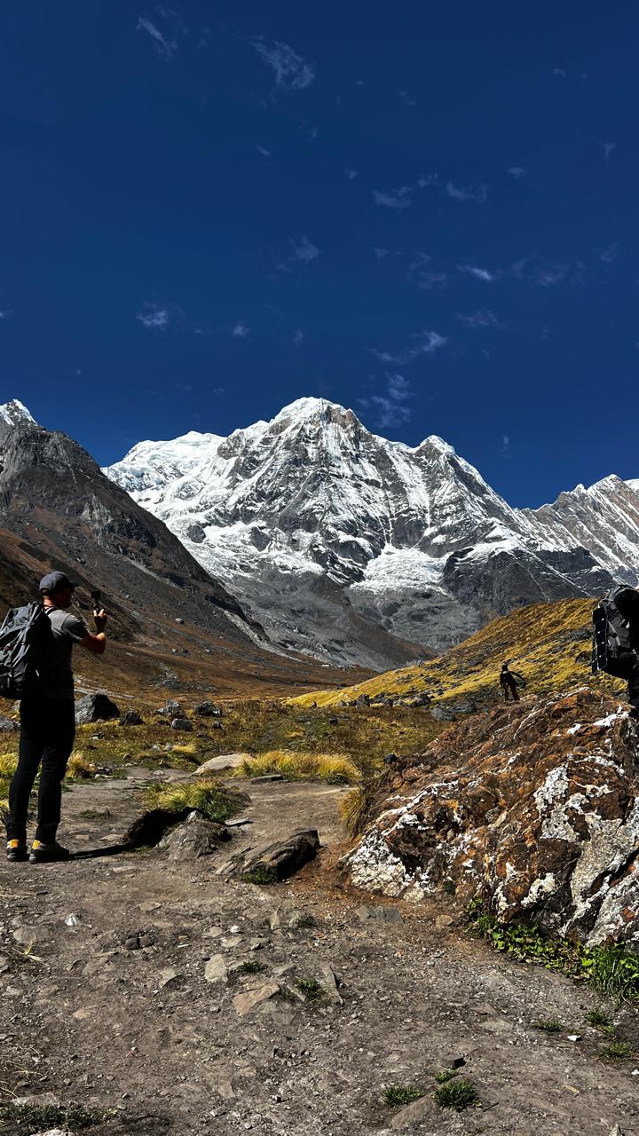
The Annapurna Circuit is one of the most varied trekking routes on Earth. Beginning near Besisahar in the subtropical Marsyangdi valley, the route climbs through dense forest and terraced farmland before the deep gorges above Chame open to the high valley with the rock walls of Paungda Danda and the peaks of Annapurna II and IV rising above. The Manang district above 3,500m is a plateau of Tibetan Buddhist culture, ancient gompas, and dramatic mountain vistas — including the spectacular Gangapurna Lake view toward Gangapurna and Tilicho Peak.
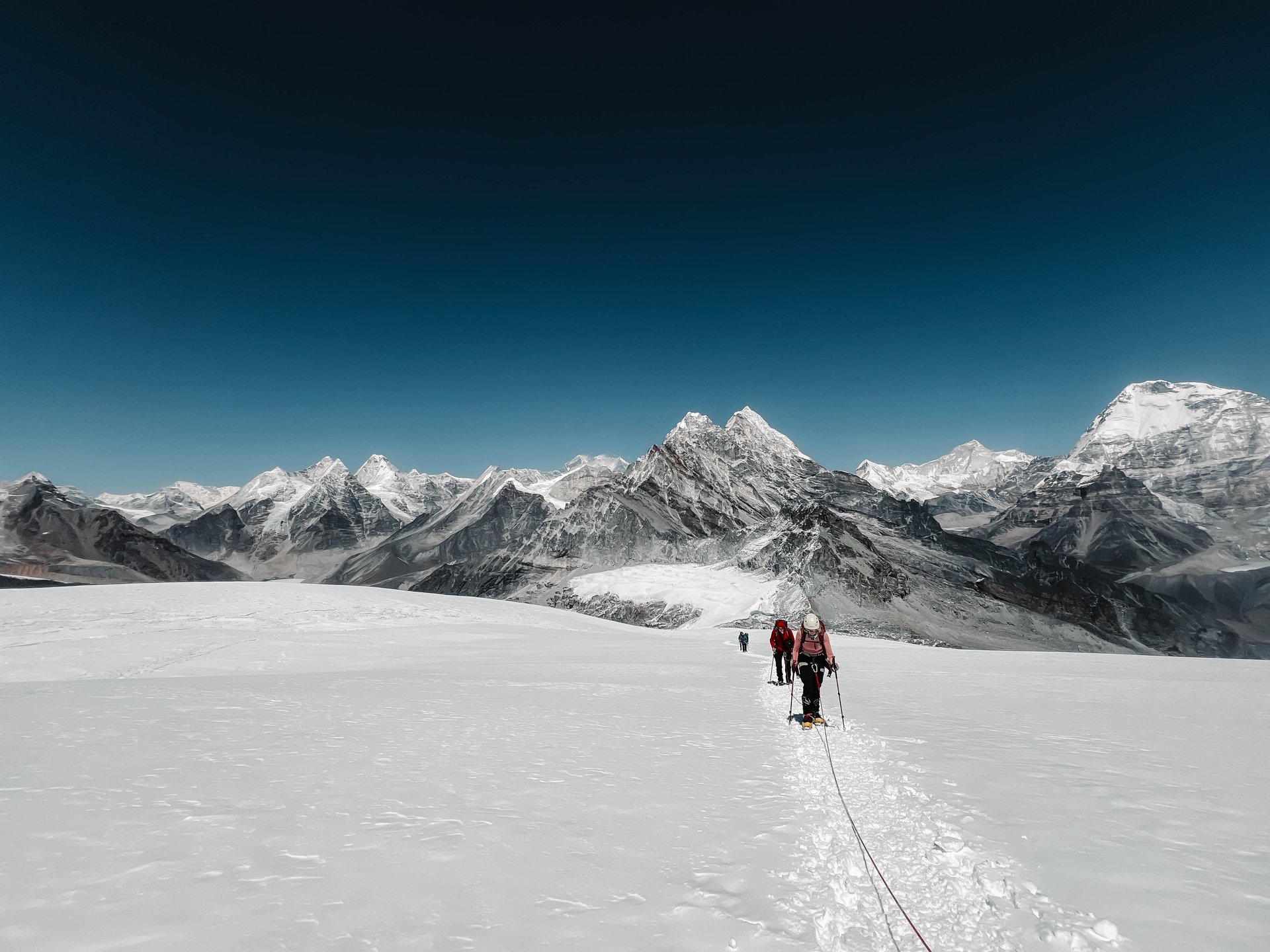
The Thorong La crossing (5,416m) is the physical and emotional centrepiece of the trek — an early morning departure from High Camp (4,925m) to the pass, followed by a long descent to Muktinath, one of the most sacred pilgrimage sites in the Hindu and Buddhist traditions.
Why Choose AltiPro Adventures for the Annapurna Circuit?
Expert Local Guides
AltiPro's Circuit guides are experienced mountain professionals with deep knowledge of the Manang and Mustang districts, the Thorong La crossing conditions, and the altitude management required for a safe and enjoyable passage.
Optimal 16-Day Itinerary
The schedule includes essential rest and acclimatisation days at Manang (3,519m) with a high hike above 4,000m, following proven altitude protocols for the Thorong La crossing — the most critical preparation on the route.
Personal Porter for Each Trekker
Dedicated porter support throughout, allowing light day-pack trekking. AltiPro maintains fair wages, insurance, and proper equipment standards for all porters — a non-negotiable commitment on every trek.
Small Group Size
Maximum 12 trekkers for personalised guiding and flexible pacing across the full 16-day route from Besisahar to Jomsom.
Complete Logistics
All ACAP and TIMS permits, transport from Kathmandu to the trailhead, teahouse accommodation, all meals on trek, and the Jomsom-to-Pokhara domestic flight on descent — completely handled by AltiPro.
Spring and Autumn Seasons
AltiPro operates the Circuit in both spring (March–May) and autumn (October–November). Spring offers spectacular rhododendron blooms below 4,000m; autumn delivers the clearest skies and most stable Thorong La conditions.
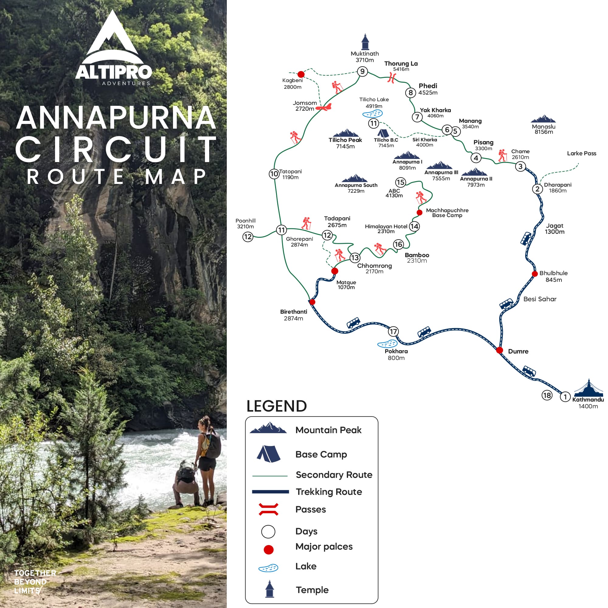
Annapurna Circuit Trek — 16-Day Route Overview
The Circuit climbs from the subtropical Marsyangdi valley through the Manang high desert to the Thorong La (5,416m), then descends through the Kali Gandaki gorge — the world's deepest — to Jomsom and Pokhara.
Days 1–2: Kathmandu → Besisahar (760m) → Bahundanda
Drive from Kathmandu to Besisahar and begin trekking through the subtropical lower Marsyangdi valley — lush, warm, and in dramatic contrast to the high passes ahead.
Days 3–5: Chame (2,710m) → Manang (3,519m) via Pisang
Above Chame the valley narrows dramatically with the Paungda Danda rock wall rising on the right. Pisang Peak (6,091m) dominates the approach to Pisang village. The landscape shifts progressively from forest to high-altitude tundra as the route enters the Manang district.
Days 6–7: Manang Acclimatisation + Ice Lake (4,600m)
Two essential acclimatisation days at Manang before the Thorong La. The Ice Lake hike above 4,600m is an excellent altitude preparation and delivers outstanding views of Annapurna III, Gangapurna, and Tilicho Peak from the lake shore.
Days 8–9: High Camp (4,925m) → Thorong La (5,416m) → Muktinath (3,760m)
The centrepiece of the Circuit. Pre-dawn departure from High Camp, 5 to 7 hours to the pass with panoramic views across the entire Annapurna and Muktinath range, then a long descent to the sacred pilgrimage town of Muktinath.
Days 10–12: Muktinath → Kagbeni → Marpha via Kali Gandaki
The Kali Gandaki gorge section — the world's deepest gorge — passes through the arid rain-shadow landscape of Mustang with the Dhaulagiri and Nilgiri massifs flanking the valley in a dramatic high-altitude desert panorama.
Days 13–16: Jomsom → Pokhara (domestic flight)
Descent via the lower Kali Gandaki through apple orchards and subtropical valley to Jomsom for the domestic flight to Pokhara, completing the full Annapurna Circuit from Besisahar to Jomsom.
How Difficult is the Annapurna Circuit Trek?
The Annapurna Circuit is rated Challenging. The main challenge is the Thorong La crossing at 5,416m, requiring strong acclimatisation and sustained fitness over 16 days. The route is non-technical throughout — the demands are physical and altitude-related, not technical climbing.
Best Season for the Annapurna Circuit Trek
Autumn (October–November): The primary season for the Annapurna Circuit — clear post-monsoon skies and the most stable Thorong La conditions. October is the single best month.
Spring (March–May): Excellent spring conditions with rhododendron blooms below 4,000m. April and May are ideal before the monsoon, with fewer trekkers than the October peak.
Annapurna Circuit Trek Cost
Fully guided Annapurna Circuit — all permits, transport, teahouse accommodation, meals, guide, porter, and Jomsom–Pokhara flight included.
Includes all ACAP and TIMS permits, transport Kathmandu–Besisahar, all teahouse accommodation and meals on trek, licensed guide, personal porter for each trekker, and Jomsom–Pokhara domestic return flight. International flights and personal trekking equipment are not included. Contact AltiPro for a full cost breakdown.
Annapurna Circuit Trek — Frequently Asked Questions
Common questions about the Annapurna Circuit Trek with AltiPro Adventures.
How hard is the Thorong La crossing?
Thorong La at 5,416m is demanding but achievable for well-prepared trekkers following a proper acclimatisation schedule. AltiPro's itinerary includes mandatory rest and acclimatisation days at Manang before the crossing.
How long is the Annapurna Circuit?
16 days with AltiPro, from Kathmandu to Pokhara, including all trekking and acclimatisation days, the Thorong La crossing, and the Jomsom-to-Pokhara descent flight.
What is included in AltiPro's package?
All ACAP and TIMS permits, transport Kathmandu-to-trailhead, all teahouse accommodation and meals on trek, licensed guide, personal porter, and Jomsom-Pokhara domestic flight. International flights and personal gear are not included.
When is the best time for the Annapurna Circuit?
October for the clearest post-monsoon skies and most stable Thorong La conditions. April for spring rhododendrons and smaller crowds than the October peak season.
Do I need prior trekking experience?
Yes. AltiPro recommends prior trekking experience above 3,500m. The 16-day sustained effort and the 5,416m Thorong La crossing require solid fitness and some prior altitude experience.
Is the Circuit still worthwhile after road construction?
Yes. AltiPro's guided itinerary follows the traditional trekking trail sections, avoiding road sections wherever possible. The upper Manang, Thorong La, and Mustang sections remain completely unspoiled.
What is the highest sleeping altitude?
Thorong High Camp at 4,925m the night before the pass crossing. Most trekkers also sleep two nights at Manang (3,519m) for acclimatisation before ascending to High Camp.
What if weather closes the Thorong La?
AltiPro's guides monitor weather conditions daily. If the pass is unsafe, the team waits at Manang or High Camp for a safe weather window. Thorong La closures are uncommon in October but possible in spring.
Highlights
- Thorong La Pass (5,416 m) — The Defining Crossing
- 230 km Through Eight Climatic Zones
- Muktinath — Sacred Compound at 3,710 m
- Kali Gandaki Gorge — World's Deepest
- Manang Valley & Braga Monastery (500 Years Old)
- Ice Lake (4,600 m) — The Circuit's Finest Day Hike
- Marpha Apple Orchards & Kali Gandaki Wind Valley
- Jomsom to Pokhara — 20-Minute Mountain Flight
Detailed Itinerary
Click on each day to view details
| Day | Program | Meals | Accom. | |||||||||||||||||||||||||||||||||||||||||||||||||||||||||||||||||||||||||||||||||||||||||||||||||||||||||||||||||||||||||||||||||||||||||||||||||||||||||||||||||||||||||||
|---|---|---|---|---|---|---|---|---|---|---|---|---|---|---|---|---|---|---|---|---|---|---|---|---|---|---|---|---|---|---|---|---|---|---|---|---|---|---|---|---|---|---|---|---|---|---|---|---|---|---|---|---|---|---|---|---|---|---|---|---|---|---|---|---|---|---|---|---|---|---|---|---|---|---|---|---|---|---|---|---|---|---|---|---|---|---|---|---|---|---|---|---|---|---|---|---|---|---|---|---|---|---|---|---|---|---|---|---|---|---|---|---|---|---|---|---|---|---|---|---|---|---|---|---|---|---|---|---|---|---|---|---|---|---|---|---|---|---|---|---|---|---|---|---|---|---|---|---|---|---|---|---|---|---|---|---|---|---|---|---|---|---|---|---|---|---|---|---|---|---|---|---|---|---|
| 1 | Arrival in Kathmandu (1,350 m / 4,429 ft) | D | Hotel | |||||||||||||||||||||||||||||||||||||||||||||||||||||||||||||||||||||||||||||||||||||||||||||||||||||||||||||||||||||||||||||||||||||||||||||||||||||||||||||||||||||||||||
|
Arrive in Kathmandu and transfer to your hotel. Meet your AltiPro guide for the welcome dinner and full Annapurna Circuit Trek 2027 briefing — permits, packing and what to expect on the circuit.
2
|
Kathmandu — Permit Processing & Trek Preparation |
B,D |
Hotel |
|
| Collect your ACAP and MCAP permits in Kathmandu. Full gear check, trek briefing, and porter bag preparation. Free afternoon to explore Kathmandu.
3
|
Drive Kathmandu → Besisahar → Bhulbhule / Ngadi (840 m) |
B,L,D |
Lodge |
|
| A 7–8 hour drive to Besisahar begins the Annapurna Circuit. The trek starts along the Marsyangdi River through subtropical forest and terraced farmlands, passing Gurung villages. The valley is wide, lush and green. 4–5 hrs walking.
4
|
Trek Bhulbhule → Jagat (1,300 m / 4,265 ft) |
B,L,D |
Lodge |
|
| Suspension bridges over the Marsyangdi lead to Jagat where ACAP and MCAP permits are checked. The river gorge narrows and steepens above. 5–6 hrs walking.
5
|
Trek Jagat → Dharapani (1,860 m) → Bagarchhap (2,160 m) |
B,L,D |
Lodge |
|
| The valley widens above Dharapani where the Manaslu Circuit route joins the Annapurna Circuit. First fir and pine forest appears, and the first views of Manaslu (8,163 m) come into sight. 5–6 hrs walking.
6
|
Trek Bagarchhap → Chame (2,670 m / 8,760 ft) |
B,L,D |
Lodge |
|
| A dramatic gorge and impressive waterfalls lead to Chame, the Manang district headquarters — the last reliable ATM and supplies before the upper circuit. Annapurna II (7,937 m) appears for the first time. 5–6 hrs walking.
7
|
Trek Chame → Upper Pisang (3,310 m / 10,859 ft) |
B,L,D |
Lodge |
|
| Above Chame the valley opens into classic mountain scenery. The option to take the upper ridge trail to Upper Pisang delivers spectacular Pisang Peak (6,091 m) and Annapurna II panoramas. Upper Pisang sits on the ridge with the finest views of the circuit so far. 5–6 hrs walking.
8
|
Trek Upper Pisang → Braga (3,475 m) → Manang (3,519 m) |
B,L,D |
Lodge |
|
| Visit Braga Monastery — 500 years old and perched dramatically above the valley. Arrive in Manang (3,519 m), the acclimatisation base of the circuit, with full Annapurna and Gangapurna views from the village rooftops. The Manang Mountaineering Museum is worth a visit. 4–5 hrs walking.
9
|
Acclimatisation Day — Manang (3,519 m) — Ice Lake (4,600 m) or Gangapurna Lake |
B,L,D |
Lodge |
|
| A mandatory rest day before the Thorong La crossing. Option to hike to Gangapurna Lake (3,700 m) for a gentle acclimatisation walk, or Ice Lake (4,600 m / 15,092 ft) for the highest and most spectacular viewpoint before the pass — 360-degree views of Annapurna III, Gangapurna and Tilicho Peak. AltiPro attends the Himalayan Rescue Association altitude briefing in Manang.
10
|
Trek Manang → Yak Kharka (4,018 m / 13,182 ft) |
B,L,D |
Lodge |
|
| Above treeline, the trail crosses into the barren upper Marsyangdi valley. The last vegetation disappears. Altitude effects become noticeable above 4,000 m — walk slowly, drink plenty of water. A deliberately short day to aid acclimatisation. 3–4 hrs walking.
11
|
Trek Yak Kharka → Thorong Phedi / High Camp (4,450–4,875 m) |
B,L,D |
Lodge |
|
| A short but critical day — early arrival at Thorong Phedi (4,450 m) or High Camp (4,875 m) is essential before tomorrow's crossing. Oxygen levels at High Camp are approximately 55% of sea level. Rest, hydrate and prepare kit for the pre-dawn start. 2–3 hrs walking.
12
|
THORONG LA CROSSING — Thorong Phedi → Pass (5,416 m) → Muktinath (3,710 m) |
B,L,D |
Lodge |
|
| Pre-dawn departure (4–5 AM). A 966 m ascent to Thorong La Pass (5,416 m / 17,769 ft) — prayer flags, cairns and the full Annapurna range on the horizon. A 1,706 m descent to Muktinath (3,710 m): sacred compound of 108 water spouts, an eternal flame temple and ancient Buddhist shrines. The defining day of the Annapurna Circuit. 10–12 hrs total.
13
|
Muktinath → Kagbeni (2,810 m / 9,219 ft) |
B,L,D |
Lodge |
|
| Visit the Muktinath temple complex in the morning, then descend through Jharkot and Khinga villages to Kagbeni — a medieval walled town and the gateway to restricted Upper Mustang. The landscapes are increasingly arid, dramatic and Tibetan in character. 4–5 hrs walking.
14
|
Trek Kagbeni → Marpha (2,667 m / 8,750 ft) |
B,L,D |
Lodge |
|
| Follow the Kali Gandaki wind-valley south through the arid Mustang landscape. Marpha is famous for its apple orchards and apple brandy — the village whitewashed lanes and Tibetan architecture are some of the finest on the circuit. Tukuche Peak (6,920 m) dominates the horizon. 4–5 hrs walking.
15
|
Trek Marpha → Jomsom (2,670 m) — Fly to Pokhara |
B,D |
Hotel |
|
| A short final trekking day to Jomsom (2,670 m). Morning flight Jomsom → Pokhara (20 minutes) over the Annapurna range. The circuit is complete. Transfer to hotel in Pokhara for a well-earned rest. The Jomsom flight is one of the most dramatic short mountain flights in Nepal.
16
|
Pokhara Leisure Day — Drive or Fly to Kathmandu |
B,D |
Hotel |
|
| A relaxed day in Pokhara — optional boat trip on Phewa Lake, visit to the World Peace Pagoda, or simply rest. Drive or fly back to Kathmandu in the afternoon. Farewell dinner with your AltiPro team. Annapurna Circuit Trek certificate presented.
17
|
Buffer Day — Kathmandu / Pokhara |
B |
Hotel |
|
| Reserved as a buffer for Jomsom flight cancellations, weather delays on Thorong La, or an optional extension to Poon Hill and Ghorepani (3,210 m) — one of Nepal's finest sunrise viewpoints. If not needed, free day in Kathmandu or Pokhara.
18
|
Final Departure from Kathmandu |
B |
None |
|
| Transfer to Tribhuvan International Airport for your onward flight. Your AltiPro team will see you off. The circuit, the pass, the gorge and the people of the Annapurna region will stay with you for a long time. | ||||||||||||||||||||||||||||||||||||||||||||||||||||||||||||||||||||||||
Services
Includes
- ✅ Annapurna Conservation Area Permit (ACAP) — NPR 3,000 per person
- ✅ Manaslu Conservation Area Permit (MCAP) — for full Besisahar–Jagat entry section
- ✅ Licensed guide included and arranged — mandatory per Nepal government regulation
- ✅ Nepal government taxes and company service charges
- ✅ Airport pick-up and drop — private vehicle
- ✅ 3 nights hotel in Kathmandu (BB) — single room
- ✅ 1 night hotel in Pokhara (BB) — single room
- ✅ Welcome dinner in Kathmandu and farewell dinner in Pokhara or Kathmandu
- ✅ Annapurna Circuit trek map, NATT trail guide and route notes. One AltiPro Adventures duffle bag.
- ✅ Domestic flight or vehicle: Kathmandu to Pokhara and return
- ✅ Private jeep / vehicle: Pokhara to Besisahar (trek start)
- ✅ Domestic flight: Jomsom to Pokhara (circuit exit) — 20 min flight
- ✅ All Nepalese staff transport costs throughout the trip
- ✅ Experienced, government-licensed English-speaking trekking guide for the full circuit
- ✅ Porter support — up to 15 kg per member, Besisahar to Jomsom
- ✅ All Nepalese staff and porter daily wages, salary, equipment, food and clothing
- ✅ Full board teahouse accommodation throughout the circuit (twin rooms where available)
- ✅ 3 meals per day (BLD) — breakfast, lunch, dinner throughout the trek
- ✅ Tea and coffee included with all meals at teahouses
- ✅ 6-hourly weather forecast updates, especially for the Thorong La crossing window
- ✅ HRA altitude briefing attendance in Manang (when available)
- ✅ Comprehensive first aid medical kit and altitude management throughout
- ✅ Emergency evacuation coordination — helicopter standby pre-arranged from Pokhara
Excludes
- ❌ International flight airfare (to and from Kathmandu)
- ❌ Nepalese Visa fee — USD 125 for 90 days
- ❌ Personal trekking gear, clothing, boots and sleeping bag (–15°C minimum rated above Manang)
- ❌ Soaps, shampoos, toilet paper and personal hygiene items
- ❌ Meals in Kathmandu and Pokhara except included dinners
- ❌ Extra accommodation in Kathmandu or Pokhara beyond included nights
- ❌ Hot shower, device charging and Wi-Fi at teahouses (typically NPR 100–300 per use)
- ❌ Alcoholic beverages and personal purchases
- ❌ Travel, medical and helicopter rescue insurance — mandatory for all participants (strongly recommended minimum USD 100,000 cover)
- ❌ Tips for trekking guide — minimum USD 100–120 per guide
- ❌ Tips for porter — minimum USD 60–80 per porter
- ❌ Special filming, camera and drone permit fees (drones restricted in conservation area)
- ❌ Poon Hill / Ghorepani extension — available as optional upgrade on request
- ❌ Tilicho Lake side trip — available as optional 2-day extension from Manang on request
- ❌ Costs due to Jomsom flight cancellations, road disruptions or unforeseen situations
- ❌ Any other services not listed in the inclusions section above
Gear Lists & Useful Information
Route Map
Been on this trek?
Your feedback helps other travelers plan their adventure of a lifetime. Share your experience with us!
Nar Phu Valley Trek
Tilicho Lake Trek
World's Highest Glacial Lake Trek — Tilicho Lake (4,919 m), Annapurna Region
 Annapurna Region
Mardi Himal Trek
Mardi Himal Trek — Closest Machhapuchhre Views from Pokhara | AltiPro Adventures
 Annapurna Region
Annapurna Base Camp (ABC) Trek
Trek inside the Annapurna Sanctuary — the world's most beautiful glacial amphitheatre
Upper Mustang /Lo Manthang Trek
Trek to the ancient walled city of Lo Manthang in the rain-shadow kingdom of Lo.
Ready to Start Your Trekking Adventure?
Contact us to book your trek or get more information